UPDATE 07/05/22 5:30 AM – Yukon’s Highways and Public Works are reporting that the Alaska Highway is open again at Contact Creek as a one-lane detour has been created. The detour is at km 900 for southbound traffic leaving Watson Lake and km 897 for northbound traffic leaving Fort Nelson. They ask drivers to be alert for signs and follow the pilot car on site.
The Alaska Highway is again open at Contact Creek as a one-lane detour has been created.
The detour is at km 900 for southbound traffic leaving Watson Lake and km 897 for northbound traffic leaving Fort Nelson.
Please watch for signs and follow the pilot car on site.@DriveBC pic.twitter.com/clHfFX7nNm
— Yukon Highways and Public Works (@YukonHPW) July 4, 2022
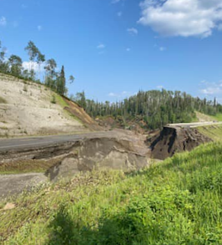
ORIGINAL: The Alaska Highway has been closed near the Liard River in British Columbia, preventing drivers from being able to take the main route connecting Alaska to the Lower 48. The road closure is located near the border with the Yukon Territory. DriveBC indicates that the road closure is due to a washout, from reported flooding and water across the road.
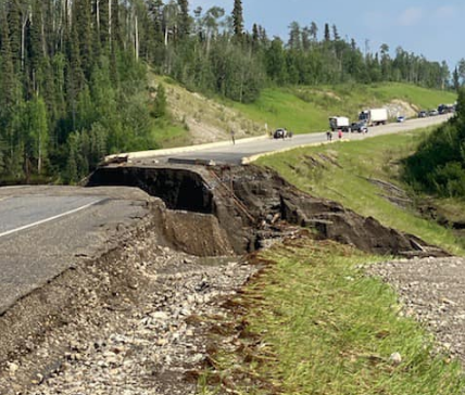
According to the Government of Yukon’s Department of Highways and Public Works, the Alaska Highway closure is located at KM 898, which is located 30-35 miles south of Watson Lake, or about 77 miles north of Liard Hot Springs on the British Columbia side of the border near Contact Creek. They do say that Highway 37 (Stewart-Cassier) remains open for use, although that adds a considerable amount of time to your trip if you’re using the Alaska Highway to get to Alaska or to the Lower 48.
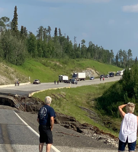
According to Yukon511, the road has been closed since July 1.
The Alaska Highway is closed about 50 to 60km south of Watson Lake on the BC side of the border.
These photos were taken at Contact Creek earlier today. #Yukon@TranBC pic.twitter.com/eHH69Axuo5
— Yukon Highways and Public Works (@YukonHPW) July 2, 2022
It is unknown how long the highway will remain closed.
Click here for updates.