The National Weather Service in Anchorage has issued a Winter Storm Watch in effect Tuesday morning, February 28th, through Wednesday morning, March 1st, for the Western & Eastern Kenai Peninsula.
Western Kenai Peninsula – Including the cities of Kenai, Soldotna, Homer, and Cooper Landing
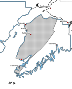 Expect widespread snow across the western Kenai, but the heaviest snow and highest snow totals are expected near Cook Inlet, including the Sterling Highway corridor from Anchor Point to Soldotna and northward to Kenai and Nikiski. There is uncertainty in when the snow will end, ranging anywhere from Wednesday morning to Wednesday evening. This will impact the amount of snow accumulation.
According to the National Weather Service, heavy snow and blowing snow possible. Total snow accumulations of 6 to 12 inches with isolated amounts up to 18 inches is possible. North winds gusting as high as 25 to 35 mph near Cook Inlet could produce white out conditions at times.
Travel could be very difficult, especially along the Sterling Highway corridor from Homer to Soldotna and northward to Kenai and Nikiski.
Western Prince William Sound – Including the cities of Whittier, Seward, Girdwood and Moose Pass
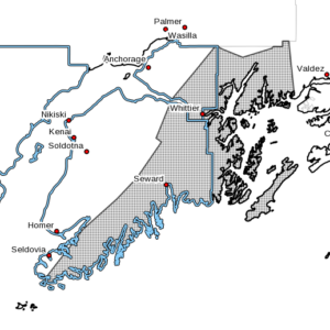 The worst conditions are expected in Whittier, Portage Valley and east Turnagain Arm due to the combination of heavy snow and blowing snow. However, all areas will likely see significant snow accumulation. There is uncertainty in when the snow will end, ranging anywhere from Wednesday morning to Wednesday evening. This will impact the amount of snow accumulation.
According to the National Weather Service, heavy snow and blowing snow possible. Total snow accumulations 12 to 24 inches with localized higher amounts is possible. East winds gusting as high as 20 to 35 mph, strongest through Portage Valley and eastern Turnagain Arm, could produce white out conditions at times. Travel could be very difficult.
Monitor the latest forecasts for updates on this situation.