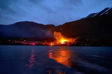
The Alaska Division of Geological & Geophysical Surveys (DGGS) released a preliminary interpretive report about a series of landslides in Wrangell on Nov. 20, 2023, the largest of which caused six fatalities with one victim remaining missing, destroyed three homes, and covered the Zimovia Highway near milepost 11.2.
“This report describes our geologists’ field investigations, methodology, and analysis of the pre- and post-landslide lidar datasets,” said Mort Larsen, Landslide Hazards Program Manager. “Our team conducted on-the-ground and aerial assessments immediately after the landslides, collected lidar data from areas of concern as identified by the community, compared the November 2023 post-landslide information to lidar data collected in July 2023, and examined rainfall and wind data to understand the weather conditions before and during the event.”
The purpose of the preliminary scientific report “Post-Landslide Elevation Changes Detected from Multi-Temporal Lidar Surveys of the November 2023 Wrangell, Alaska, Landslides” [https://doi.org/10.14509/31124] is to describe the characteristics of the landslide events that occurred on Nov. 20 on Wrangell Island. The report does not provide a comprehensive causation analysis for each specific site. DGGS concluded that the landslides, characterized as debris flows, were rain-induced. Based on weather data and after-slide monitoring, four or more inches of rain could have fallen at milepost 11.2 in the 24 hours before the Zimovia Highway landslide. Although wind gusts cannot be ruled out as a contributing factor, water-saturated soils are interpreted to be the dominant control on starting the landslides.
Zimovia Highway 11.2 landslide
- Primarily comprised of saturated soils and large woody debris
- Started at 1,490 feet above sea level
- Spanned roughly 3,750 feet on the hillside
- Extended 500 feet into the Zimovia Straight waters
- 350 feet wide where it crossed the highway
Middle Ridge Road landslide
- Primarily large woody debris and saturated soils with very little rock
- 3,600 feet long
- Covered 600 feet of Middle Ridge Road
- Lower section was 150 feet wide
“My thoughts remain with not only the victims and their families of this tragic landslide, but also the close-knit community of Wrangell,” said John Boyle, DNR Commissioner. “As a follow up to this preliminary report, DNR is pursuing FEMA funding to map the susceptibility of other slopes on Wrangell Island. We will continue to share research about landslides and other geologic hazards across Alaska through the Division of Geological & Geophysical Surveys.”
The DGGS Landslide Hazards Program conducts studies to evaluate unstable slopes and provide valuable information to policy makers, state and federal government agencies, and the general public. The website and the division’s Landslide Hazards in Alaska brochure can help Alaskans evaluate their risk, look for warning signs, and know what to do during a landslide.
A raw data file: “Lidar-Derived Elevation Data for Wrangell Island, Southeast Alaska, Collected November 28-29, 2023” is also available from https://doi.org/10.14509/31106.
Lidar, which stands for Light Detection and Ranging, is an active remote sensing method that uses timed laser pulses to measure distances to targets, in this case the Earth surface. The resulting point cloud, which is a 3D representation of the surface, can be used to produce different types of digital elevation models. Because lidar can penetrate through the tree canopy, information can be obtained about the bare ground and produce a digital terrain model. A lidar system principally consists of a laser scanner, an inertial navigation unit, and a Global Positioning System (GPS). Airplanes and helicopters are the most commonly used platforms for acquiring lidar data over broad areas.