


The entire Kenai Peninsula, as well as surrounding areas, are anticipated to receive wind chills of -20 degrees to -40 degrees.
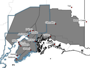
Areas expected to be affected include Anchorage-East Turnagain Arm-Matanuska Valley- Western Kenai Peninsula-Western Prince William Sound-Northeast Prince William Sound-Copper River Basin-Susitna Valley.
In regards to cities, this would affect Anchorage, Eagle River, Indian, Eklutna, Girdwood, Portage, Palmer, Wasilla, Sutton, Chickaloon, Kenai, Soldotna, Homer, Cooper Landing, Whittier, Seward, Moose Pass, Valdez, Thompson Pass, Glennallen, Eureka, McCarthy, Paxson, Slana, Talkeetna, and Willow.
According to the NWS, an arctic airmass and gusty northerly winds will move in tonight and remain in place through early this weekend.
Overnight wind chills will reach as low as -20 to -40 throughout much of Southcentral by Thursday morning. Areas that are protected from the wind will likely see similar ambient temperatures for morning lows.
Wind chills will be the most severe over mountain passes such as Isabel Pass, Mentasta Pass, Broad Pass, and Thompson Pass, where wind chill values of -40F to -50F are possible.
The coastal communities of Seward, Whittier, and Valdez will likely see warmer temperatures, but persistent gusts of 30 to 60 mph are expected through at least Friday.