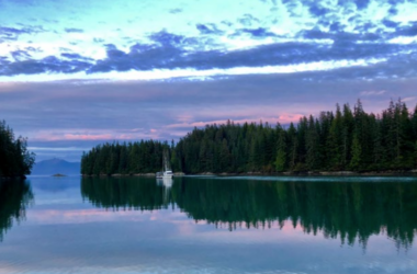
 The National Weather Service announced on Tuesday that due to flooding caused by the Moose and Skilak Glaciers-dammed lake outbursts, flood warnings along the Kenai River have been adjusted to incorporate flowing waters as far down river as the bridge in Soldotna, and have also been extended through Thursday.
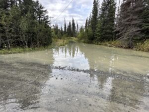
Per the latest updates from the NWS, minor flooding is projected in low-lying and poor drainage areas. This includes residential areas along the Kenai River – Big Eddy subdivision roads will have 0.5 to 1.0 feet of water over top and most low lying areas, and the NWS is warning that the subdivision will be inundated by flood waters.
According to the Director of the Kenai Peninsula Borough Office of Emergency Management, Brenda Ahlberg, a total of 613 low-lying properties abutting the river should expect to be impacted by flood waters. Impacted properties are in the Kenai Keys, Big Eddy, and near ancillary waters both upstream and downstream of Funny River off Fisherman’s Way.
Isolated homes near the Beaver Creek outlet may see some water in low lying parts of yards. Pillars boat launch will be nearly underwater.
At 9am Tuesday morning, the river level was 11.37 feet. Flood Stage is 12.0 feet, a depth the National Weather Service is projecting the Kenai River will crest roughly 4pm Wednesday to 12.2 feet.
“Right now we’re coordinating with our sister agencies at the Office of Emergency Management and our adjoining land managers, the Kenai National Wildlife Refuge, to staying, communicating with each other obviously on the state of the river and what’s happening and what private properties are flooded along the river,” said Department of Natural Resources Superintendent of Parks and Recreation, Hans Rinke. “So that that’s where we’re at now we’re this morning we’re putting in some. Wake restrictions around the community of the Kenai keys to reduce the potential for additional property damage.”
The NWS alert states, “Inherent uncertainty in initial glacier lake volume will result in varying crest height and timing.”
The Kenai Peninsula Borough Office of Emergency Management sent out an alert as well, cautioning people from taking boats out on the river.
“Do your part to help our river neighbors,” the alert stated. “Avoid motorized boating until the Kenai River recedes to safe levels; boat waves add to structure damages and bank erosion. Impacted areas include neighborhoods off of Kenai Keys Road in Sterling and roads off of Salmon Run Drive in Funny River. Farther downstream in the Big Eddy area near Soldotna, properties are also experiencing high water impacts as a result of the glacial releases and combined rain events that we’ve experienced this year. Stay safe out there folks.”
These flood warnings come at a very inconvenient time for angling enthusiasts on the peninsula, as the 7th Annual Silver Salmon Derby begins on Tuesday.
Kenai Chamber of Commerce Executive Director, Samantha Springer said the chamber is working to keep the flooding in mind as the derby is going on;
“We are monitoring the whole situation because obviously this is important. We are asking that anglers avoid using motorized vessels in the flooded areas and a lot of that can be found online. We’re gonna try and share some more information too, so that you can see exactly where you should avoid using your motorized vehicles, and we do really care and hear the homeowners that are affected by the flood area. So, We’re not ignoring that, but as long as fishing is open we will continue to keep the Derby open as well.”