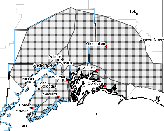
The National Weather Service in Anchorage reports that two winter storms are expected to impact Southcentral Alaska throughout the week. The active weather pattern will continue as the new work week progresses. The first system is expected to move through Southcentral Monday afternoon through Tuesday. Expect precipitation in the form of snow for all areas with snow accumulations likely. However, enough warm air may move in across the extreme southern Kenai Peninsula (including Homer) that may result in snow mixing with rain, or perhaps even simply changing to rain. Affected areas include the Kenai Peninsula, Anchorage and the Mat-Su Borough.
Snow totals will generally be in the 3 to 6 inch range for much of Southcentral. Lesser amounts are expected near Homer, where warmer temperatures may allow for some rain to mix in. The highest totals are most likely in the Valley, where heavier snow is expected. A stronger storm system moves in after midnight Tuesday night through Wednesday, with the potential for several inches of additional snow accumulation from Anchorage north, and rain mixing in for much of Southcentral south of Anchorage.
Therefore, slow down and use caution when traveling during the Monday evening commute and Tuesday morning commutes. Conditions are expected to improve as Tuesday progresses with a brief respite before the next system moves into the region late Tuesday night through Wednesday. This next system is expected to be the stronger and warmer of the two with heavier precipitation amounts possible; the warming trend may result in mixed precipitation especially on the Kenai Peninsula and coastal areas of Prince William Sound. This system may impact the morning commute on Wednesday.
For the latest forecast, visit www.weather.gov/afc. For the latest road conditions, call 511 or visit www.511.alaska.gov.


