The National Weather Service in Anchorage has issued a Winter Storm Watch in effect early Saturday morning, March 18th, through late Saturday evening, March 18th, for the Western & Eastern Kenai Peninsula.
Western Kenai Peninsula – Including the cities of Kenai, Soldotna, Homer, and Cooper Landing
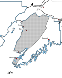 Heavy snow and blowing snow possible. Total snow accumulations of up to 6 to 13 inches possible, with the highest amounts inland toward the mountains. Winds could gust as high as 40 mph. Blowing snow is possible along the Sterling Highway from Kenai southward to Homer. Visibilities possibly dropping to one half mile or less at times.
A storm system much like the one that passed on Friday will impact the area. Heavier snow is possible toward the mountains and around Kachemak Bay. Blowing snow will be the main threat from along the Sterling Highway from Kenai southward to Homer. Monitor the latest forecasts for updates on this situation.
A winter storm means there is a potential for significant snow, sleet, or ice accumulations that may impact travel. People are encouraged to closely monitor this weather situation. Preparation for this potentially dangerous weather event should begin now.
Western Prince William Sound – Including the cities of Whittier, Seward, Girdwood and Moose Pass
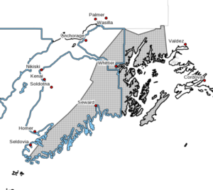 Heavy snow and blowing snow possible. Total snow accumulations of 10 to 20 inches possible. Heaviest snow accumulations along the Seward Highway from Moose Pass through Turnagain Pass. Blowing snow with visibilities reduced to one half mile or less at times, especially through Portage Valley.
A storm system very much like the one that passed on Friday will impact the area bringing another round of snow and wind. As the front passes Sunday afternoon and evening, and winds shift from north to south, strong winds will reduced visibity along the Seward Highway.
A winter storm means there is a potential for significant snow, sleet, or ice accumulations that may impact travel. People are encouraged to closely monitor this weather situation. Preparation for this potentially dangerous weather event should begin now.