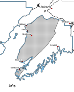
 The National Weather Service in Anchorage has issued a winter weather advisory for the Western Kenai Peninsula-including the cities of Kenai, Soldotna, Homer, and Cooper Landing, predicting snow accumulations of 4 to 10 inches, blowing snow, and winds with gusts up to 40 mph.
This advisory is in effect from 9:00 a.m. Sunday to 6:00 a.m. Monday.
According to the NWS warning, light snow will develop Sunday morning, then intensify Sunday afternoon as winds strengthen. The worst conditions are expected Sunday afternoon through Sunday evening. Visability will be reduced to one half mile or less at times.
Plan on slippery road conditions. The hazardous conditions could impact the Sunday or Monday commute. Slow down and use caution while traveling.
For those traveling to Whittier, Seward, or Moose Pass, the National Weather Service has issued a Winter Storm Warning in effect from noon Sunday to 6:00 a.m. Monday.
According to the the National Weather Service, snow will develop Sunday morning, then intensify through the afternoon and evening hours. Gusts of winds of up to 40 mph will also be expected during this time frame.
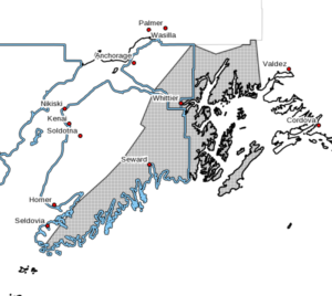
The heaviest snow will be Sunday evening through early Monday morning. Snow will mix with or change to rain overnight Sunday night through early Monday morning below 1000 feet. The duration of rain will affect the storm total snow accumulation, with the lowest amounts expected in the Seward area.
Visibility will be reduced to one quarter mile, with total snow accumulations of 15 to 30 inches, with local amounts up to 40 inches possible, and the highest amounts through Turnagain Pass and the Whittier area.
The hazardous conditions could impact the Sunday or Monday commute. Slow down and use caution while traveling.
Plan on slippery road conditions, as the hazardous conditions would impact the commute.
For the latest road conditions call 5 1 1 or visit 511.alaska.gov.