


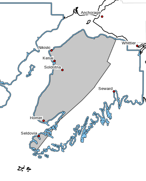

The National Weather Service in Anchorage has issued a Winter Weather Advisory in effect Midnight Saturday, December 31st, through late Sunday night, January 1st, for the Western Kenai Peninsula, including the cities of Kenai, Soldotna, Homer, and Cooper Landing.
According to the the National Weather Service, mixed precipitation is expected. Total snow accumulations of up to 1 inch and ice accumulations of a glaze up to two tenths of an inch and expected with winds gusting as high as 35 mph along Cook Inlet.
Light precipitation is expected to develop this evening through the overnight hours. Periods of precipitation will then persist through at least Sunday evening. When precipitation first arrives it will start mainly as snow, expect for rain in the Homer area and other areas near sea level along Kachemak Bay. Snow and blowing snow along the Sterling Highway from Anchor Point to Kenai could lead to low visibilities. As warmer air moves in aloft Saturday night into Sunday morning, precipitation will transition to freezing rain. Some areas will warm above freezing on Sunday, especially inland toward Cooper Landing. Areas near the Inlet will likely hover right near the freezing mark.
Travel could be hazardous. Areas of blowing snow along Cook Inlet could significantly reduce visibility. Slow down and use caution while traveling. For the latest road conditions call 5 1 1 or visit 511.alaska.gov.
Western Prince William Sound – Including the cities of Whittier, Seward, Girdwood, and Moose Pass
Winter Storm Watch in Effect from Saturday Evening through Late Sunday Night
From Saturday evening through late Sunday night, snow transitioning to mixed precipitation. Snow accumulations of 6 to 15 inches. through Turnagain Pass. Winds gusting as high as 60
mph through the northern portions of Turnagain Pass.
Travel could be extremely hazardous. Areas of blowing snow, mainly through the Turnagain Pass area could significantly reduce visibility. Strong winds could cause tree damage.
Heavy snowfall rates of one to three inches an hour are likely overnight through Summit Lake and Turnagain Pass. Snow levels will climb through Sunday afternoon, reaching between 1200 ft and 1500 ft (around the summit of Turnagain Pass and Summit Lake). This will transition precipitation from snow to a mix of rain and snow or heavy rain. Mixed precipitation or heavy rain falling onto snow covered roadways will create hazardous driving conditions. Depending on the timing of the transition between rain and snow, snow totals may be higher or lower. Heavy snow combined with strong winds, mainly through the Turnagain Pass area, could significantly reduce visibility.
High Wind Warning in Effect from Saturday Evening through Sunday 10 a.m.
East winds 30 to 40 mph with gusts up to 75 mph expected. Portage Valley and along the Seward Highway between Girdwood and Portage. From midnight tonight to 10 AM AKST Sunday.
High winds may move loose debris, damage property, and cause power outages. Travel will be difficult, especially for high profile vehicles.
Winds will increase this evening and will make travel especially difficult due to blowing snow, snow, rain and freezing rain creating low visibilities to a half mile and icy conditions.
Anchorage – Including the cities of Anchorage, Eagle River, Indian, and Eklutna
Winter Weather Advisory in Effect from 3 a.m. Sunday to Midnight Sunday Night
Snow and freezing rain expected. Total snow accumulations of up to one inch and ice accumulations of a glaze to one tenth of an inch. East winds gusting as high as 45 mph along the upper Potter Marsh and Bear Valley areas.
Light snow is expected to develop tonight and quickly change to freezing rain by Sunday morning. Periods of light freezing rain are then likely through at least Sunday evening. Temperatures will hold steady in the mid 20s to around 30, with the exception of the upper hillside which could rise in into the mid 30s during the day Sunday.